| Archaeology |
| History |
| Urban Planning |
| Agriculture |
| Landscape Ecology |
 |
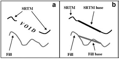
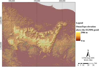
Oasis classification Objectives: Develop a typology of oases in northern Oman Contact Person: Prof. Dr. Andreas Bürkert, Institute of Crop Science, University of Kassel, Germany Email: tropcrops@uni-kassel.de Scientific staff: Dr. Eike Luedeling and Dr. Stefan Siebert Study area: Northern Oman Duration: 2005-2007 Improving the SRTM model Many environmental studies on the landscape level require topographic information, which is often derived from digital elevation models (DEMs). For the Oman Mountains, such DEMs are scarce, and their quality is relatively low. The best model available to date is the DEM derived from the Shuttle Radar Topography Mission (SRTM), which provides a spatial resolution of 90 m with a fairly high vertical accuracy. The method used to create this model, however, was impaired by rough topography, where no topographic information could be obtained. Since one of the defining characteristics of many mountain oases in Oman is their location in rough terrain, oases often lie in data voids, which cover a substantial part of the Oman Mountains. As a preparatory step for landscape ecological studies, these voids first had to be filled.
This project aimed at filling the data voids based on supplemental topographic information derived from digitized Russian military maps. For each data void within the Oman Mountains, points around the edge of the void were extracted, and a Triangular Irregular Network was constructed through these points. A corresponding surface was created for a DEM derived from the Russian maps. After correcting the latter surface for the elevation difference between the two TIN surfaces, the elevation models could seamlessly be merged (Figure 1). The resulting elevation model covered all of the Oman Mountains (Figure 2), and verification by a large number of GPS locations throughout the study area indicated that the accuracy was suitable for large scale ecological studies.
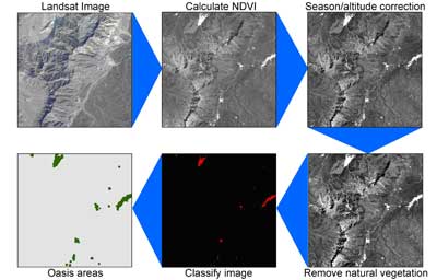
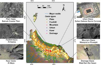
Typology of oases in Oman Northern Oman contains a large number of oases, but the exact number of such settlements is unknown. Research on these oases is also hindered by the lack of a classification system for these oases. This knowledge gap was addressed by deriving a typology of oases in Oman based on a digital elevation model, Landsat images and geological survey data.
Publications
|
|||||||||||||||||||