| Archaeology |
| History |
| Urban Planning |
| Agriculture |
| Landscape Ecology |
 |
Objectives: One of the main research tasks assumed by the architects / urban planners was the documentation and analysis of the transformation process of settlement structures and infrastructure network in a historical context and the presentation of problems and perspectives for future development. Contact Person: Dr. Anette Gangler, Institute for Urban Development Prof. Dr. E. Ribbeck / University of Stuttgart Study area: In different zones of Northern Oman the diversity of Omani oases is rendered evident by mountain oases such as Balad Seet, Misfat al-Abriyin, Haret al Bilad and Haret al Saab in the valleys of the Jabal Akhtar or in the villages of the Wadi Tiwi in the Sharqiyaa region, as well as by the inner Omani oases of different scales and functions such as Hamra and the urban Omani oases such as Ibra and Nizwa. Duration: 2001-2008
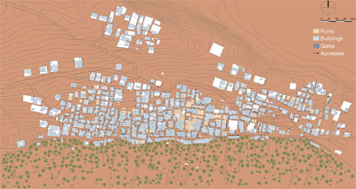
Introduction The topography, climate and natural and human resources as well as historical factors determine the traditional settlement pattern and architecture of northern Oman’s oasis civilization. The contrast in natural living conditions in the different zones of northern Oman has created the diversity and unity of Omani oasis settlements. Due to the climate and water resources the traditional Oasis Settlements were adapted to the extreme environment and created a kind of sustainable development which was necessary to survive and from which we can learn some principles of sustainable development and we can use the knowledge for the future. Due to immense industrial and technological developments, oases ceased their former agriculturally based role in the late 20th century. Modern changes have left their impact upon oasis settlements. Not only are the old settlements, which have already been given up by their inhabitants, in a state of deterioration, the whole environment and infrastructure network – the cultural landscape - are facing destruction. On the basis of satellite images of Northern Oman, detailed satellite photos of surveyed regions and aerial photos (scale 1:20.000), basic maps were established to show the topographic preconditions of the surveyed areas. Low altitude, high-resolution aerial photography ensure precise records.. On the basis of this material, urban analyses on scales of 1:1000 and 1:500 were compiled and individual buildings were measured and drawn (scale 1:200 and 1:100).
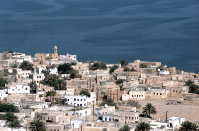
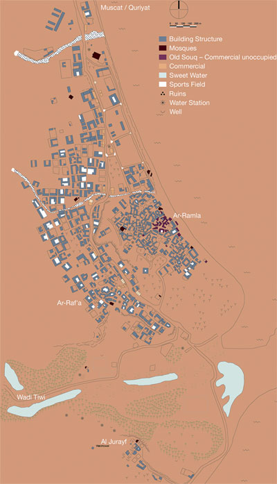
The coastal areas of Oman are oriented to Africa and India and in history the naval power of Oman was very important. In our days the geostrategic location is again very important. Tiwi is a small port on the coastal route between Quriyat and Sur. The water resources of Wadi Tiwi also gave rise to a coastal settlement in the past. But maritime trade has become insignificant and the traditional souk with approximately fifty shops is empty and in dilapidation. The economic basis of Tiwi's existence has been lost, but its accessibility has been improved due to the construction of a new asphalt road. The coastal area and the impressive and still largely undisturbed environment of Wadi Tiwi attract foreign and native tourists.
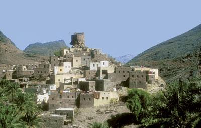
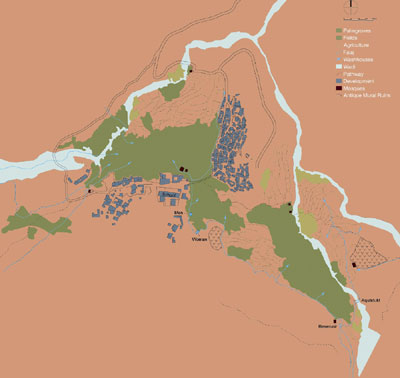
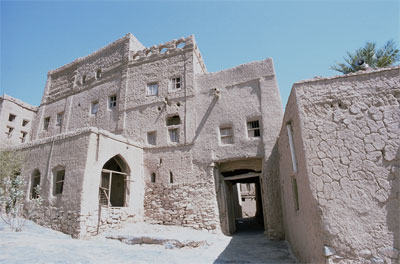
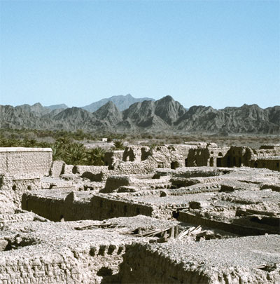
Balad Seet as an example for the mountain villages is the largest village of the Wadi Bani Awf region. The settlement is situated on the western slope of a hill and towered by an ancient fortification. The geographical and topographic position was not only popular for strategic reasons, climatic aspects and the availability of cultivable terrain for agriculture were also decisive factors encouraging settlement. Seven aflag (water canals) supply the terraced fields and palm gardens with water from sources in the mountains. It was an ecological system over hundred of years which reflects the social network and characterizes the settlement. These traditional structures have been destroyed however and the buildings – built in stone - are in a state of dilapidation. But Balad Seet is characteristic of numerous mountain oases and their locations in the mountains are becoming popular destinations and can be given a new lease of life thanks to “gentle tourism”. Strategies, planning and measures aimed at redevelopment on various levels.
At the foot of Jebel Akhdar, on the edge of the desert we find another type of settlement. Several years ago, the buildings were given up, the doors were closed and the buildings were allowed to deteriorate slowly. The location of the old town of al-Hamra provides the settlement with natural protection. The falaj determined the structure of the settlement and the position of the palm gardens, and the grain and vegetable fields.
The houses are isolated complexes of mud brick on stone foundations. With little daily temperature variation the mud building helped to maintain a stable thermal mass. The houses are built along a rocky slope. This saves agricultural land and helps to collect rain water for irrigation. The houses are oriented to the south, which reduces solar gain in summer and catches the breeze from the valley. Along narrow streets the houses are clustered together to provide shade and trap cool night air.
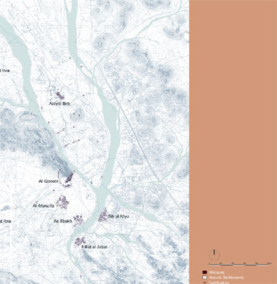
Inner Urban Omani Oasis - IBRA Ibra is the capital of the province of Sharqiya and is home to approximately 25 000 inhabitants.The town is located at the base of the eastern Hadjar Mountains at the confluence of two large wadis. A complex falaj system diverted from different wadis, guarantees a continuous water supply. This water supply and tribal membership produce the polycentric settlement form in Ibra. Further up the wadi lies the territory of Upper Ibra, which is more of an open range, in contrast to Lower Ibra, which consists of many smaller and connected districts. In both main districts of Alayat Ibra, as well as in Soufalat Ibra there are Friday mosques and large souk areas at the districts’ entrances as denoting their status as independent centres. Numerous peel towers provided the complete oasis with an external fortification against enemies. The individual town centres themselves were protected by way of fortified walls and town gates. In Qanatir, the traditional capital of the Lower Ibra, these defensive structures and the central functions of water distribution, the Friday mosque, souk and urban living complexes are still evident as a defined unit. Despite the destruction of settlement structure, social unity and the organization and interaction of a tribal group are still recognizable. The traditional economic basis in Ibra was agriculture. Today, the economic significance of Ibra is above all derived from its role as a commercial and service centre for the inland Sharqqiya. Radical structural change and strong population growth have led to the erection of whole new city districts.The traditional infrastructure are more or less destroyed and replaced by the modern infrastructure. A band-like settlement of more than 20 km in length has developed along with the building of the new road connecting Muscat with Sur.
Inner Urban Omani Oasis - Nizwa
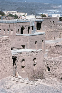
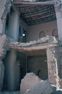
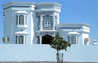
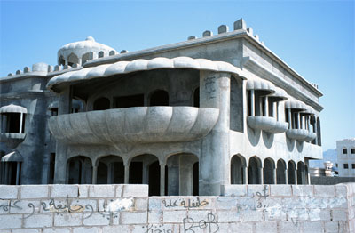
Nizwa is now the second largest city in Oman and the centre of Inner Oman with a population of approximately 70,000 inhabitants. Extensive date palm plantations once formed the economic livelihood of this oasis and comprise approximately 600 hectares of land. The ratio of settlement land to palm garden land was approximately 1:20. The oasis of Nizwa is also situated at the confluence of two wadis, from which an extensive irrigation system branches off. The most important main canal is the “Falaj Daris”, which traverses the oasis from the north flowing in a southerly direction. The centre of the old town is made up of a monumental fortress, the Sultan Quaboos Mosque and a large souk. These monuments are of great significance as regards their local and regional supply function and were renovated as part of an extensive restoration project from 1990 to 1995. They keep the historical town with around 300 traditional loam houses alive and render Nizwa a tourist attraction. Except for numerous mosques and summer residences, the palm gardens have been strictly protected from building developments. Thus, defensive buildings and the polycentric distribution of small, fortified settlement centres characterize the traditional structure of the settlement. Today, Nizwa is a regional centre and attractive residential location. A third of its inhabitants live in the traditional oasis. The old historic settlement centres such as Souweik and Madde are in a state of dilapidation however. The fortified walls and defensive buildings are no longer required, new buildings have replaced the district mosques and the residential buildings were abandoned long ago. At the same time, however, resettlement in the palm gardens has assumed critical proportions with the erection of more than 3000 new buildings. New types of buildings in the form of two-story villas are being erected either in isolated locations or in irregular rows and clusters along passable roads. As a result of increased building activities and the expansion of asphalt roads, the area of arable land still available is being reduced increasingly rapidly. The town structure of Nizwa has changed dramatically and a new commercial corridor is developing along the main road. A new traffic network, comprising a main road that bypasses the centre as well as several ring roads and bypass roads, ensures good accessibility for a housing area as regards new administrative buildings, schools, hospitals and modern shopping areas as well as extensive, new residential areas particularly in the south of the whole area. A new development area comprising approximately 600 ha has been passed as building land for approximately 4000 new houses accommodating 30,000 inhabitants in the east of Nizwa. The size of this development area roughly corresponds to that of the traditional oasis. Its density is 15 times less however and its share of accessibility-related areas and public areas is 50%. The residential quarters are not anymore organized along climatic, social and cultural aspects but according to income and wealth or poverty. A characteristic element of this town planning structure is the freestanding villa, the typical “Omani villa” with large windows and a decorative façade. This housing model is practically the complete opposite of the traditional and compact town of loam-built dwellings. The new housing form constitutes a drastic change involving the extensive consumption of land, water and energy.
Not only the restoration of the historic monuments should be taken into consideration also the preservation of the traditional urban fabric and street pattern, the historic functions and the historic landscape are creating a specific identity of the space. One of the main objectives should be retaining cultural significance through rehabilitation. Comprehensive surveys and analysis for the whole area are important to understand the traditional structures and the new development. To deal with the structural and functional changes it is necessary to develop strategies, programs and measures to avoid the dilapidation of existing structures and to integrate them into the new development and to create interaction and synergies between old and new settlements – between the past and the future. |
||||||||
|
||||||||
© Anette Gangler
|
||||||||